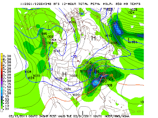
Hello folks. Happy Valentine Day. I took a little break. The weather been very nice and will continue to be nice today. Highs in the low to mid 50's. Increasing clouds late. A few showers tomorrow highs in the mid to upper 50's.Breezy day as well. High Thursday highs likely will get 70 now. Less clouds and showers staying north and west of us along with windy conditions temperatures will soar. Thursday night- Friday rain will move in along with windy conditions as the front pushes through. Saturday will be little cooler. Highs around 50. Early next week an intensfying low perssure system that looks to bring a chance of strong to severe t-storms and strong winds Monday. Highs well into the 60's. Back and forth temperatures trends next week. Here gfs for next Monday and powerful low pressure system about 990 mb in the Western Lakes. Lines of strong and severe storms we will have to watch. Winds gusting over 40mph.
Our next winter storm to track between Feburary 28 and March 2nd to track then extreme cold behind this storm. We should be ready to track snow at time period.


No comments:
Post a Comment