
Wednesday, November 30, 2011
Clouds will take a while to leave today and a nice ending to the week
Highs ranging from the the upper 30's to low 40's depending on how much sun we can get later. Lows tonight about 28. Temperatures rebounding to 50 on Thursday to start the 1st of December(my favorite month and my birthday month). Even warmer Friday Low 50's Friday. Upper 50's and a breezy afternoon Saturday. A beautiful ending of the week. Early next week another heavy rain event starting Sunday. Windy day. Highs upper 50's. A front will put the breaks on Monday with heavy rain continuing. We have watch a wave of low preesure and cold air behind the front to see it's impact the region. Plenty time to fine tuned the forecast. Here the rainfall amount thru Monday am. 1.00-1.25 western and central part of the state. We are 1.75" from the yearly rainfall record. We could challenge this.

Tuesday, November 29, 2011
Backlash rain/snow this evening thru overnight
Temperatures will continue to drop slowly and hopefully we can see my snow accumulations I expected to see before this month comes to a close. .01 will be classfied as snow accumulations. We standing at 36 as I write. Low tonight will reach 32 degrees.No problems in the morning with cloudy skies. More updates in the am on Clouds for Wednesday and sneak look at early next week weather.
Monday, November 28, 2011
Snow breaking out in the afternoon Tuesday thru Tuesday night
1" or less wet snow is expected with the track of upper low looking to be being further west. Snow accumulations mainly on the grassy areas. Winds will increasing during the afternoon and evening. Temperatures dropping in the 30's with wind chills in the upper 20's. Highs will occur early in the 40's. If we stay cloudy Wednesday we will stay in the 30's more sun pm low 40's. One day near or around 50 Thursday. The weekend will be in the 50's. Another storm system late weekend/early next week is being watch. More on that as week wears on. Lets get through the snow Tuesday.
upper 40's later today then fallng temperatures falling into the 30's with wet snow
Heavy rain this afternoon and evening. More rain Tuesday changing to snow Snow accumulation is expected but nothing big. How much exactly we see will determine the track of upper low to the south today? Areas to the south in or around Memphis my hometown expected 2 up to 6" of snow. Models shows us <1" but if we see track upper low track e-tn and e.ky will see more. More updates on snow later.
Sunday, November 27, 2011
Flood watch for most of state; Snow acculation is expected but not a big snow
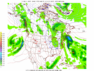
Over half in inch of rain as of early evening. Another 1-2" rain expected thru Wednesday am. More heavy rain Monday afternoon and evening. Highs will be in the mid 40's. Lows tonight and tomorrow night 40 degrees. Winds becoming gusty Tuesday with rain changing to wet snow. High 40 and dropping into the 30's late. It will feel like upper 20's being out there. Snow will continue through the night ending Wednesday am. Snow accumulation is expected but not a big snow producer. Low Wednesday am near 30. If we stay cloudy we will stay in the 30's for high temperatures. More sun into low to mid 40's. Tricky forecast. We will see no 50's this week. Even colder next week to start December. Here is upper low that Euro is seeing Tuesday am in the NW AL. It will move ne toward us and change rain to snow.


Saturday, November 26, 2011
Winter forecast 2011-2012

Table 1. Forecast SST Anomalies (deg C) in the Nino 3.4 Region
| Seasons (2011-2012) | |||||||||
| Model | NDJ | DJF | JFM | FMA | MAM | AMJ | MJJ | JJA | JAS |
| Dynamical models | |||||||||
| NASA GMAO model | -1.7 | -1.9 | -2 | -1.8 | -1.6 | -1.3 | -1.1 | ||
| NCEP Coupled Fcst Sys model | -1.1 | -1.2 | -1.1 | -0.9 | -0.8 | -0.8 | -0.8 | -0.8 | |
| Japan Met. Agency model | -0.6 | -0.5 | -0.3 | -0.1 | 0.1 | ||||
| Scripps Inst. HCM | -0.8 | -1 | -1.1 | -1 | -0.8 | -0.7 | -0.5 | -0.3 | -0.1 |
| Lamont-Doherty model | -0.7 | -0.5 | -0.3 | -0.2 | 0.1 | 0.4 | 0.7 | 0.8 | 0.9 |
| POAMA (Austr) model | -0.7 | -0.4 | -0.2 | 0 | 0.2 | 0.4 | |||
| ECMWF model | -1.1 | -1 | -0.8 | -0.5 | |||||
| UKMO model | -1.5 | -1.3 | -1.1 | -0.9 | |||||
| KMA (Korea) SNU model | -0.6 | -0.4 | -0.3 | -0.1 | -0 | 0.1 | 0.1 | 0.2 | 0.2 |
| ESSIC Intermed. Coupled model | -0.9 | -0.7 | -0.5 | -0.3 | -0.2 | -0 | 0.1 | 0.1 | 0.2 |
| ECHAM/MOM | -1 | -0.8 | -0.5 | -0.3 | -0 | ||||
| COLA ANOM | -0.4 | -0.4 | -0.4 | -0.3 | -0.2 | -0.3 | -0.4 | -0.5 | -0.6 |
| MÉTÉO FRANCE model | -0.7 | -0.5 | -0.4 | -0.3 | -0.2 | ||||
| COLA CCSM3 model | -0 | 0.1 | 0.1 | 0.2 | 0.3 | 0.4 | 0.5 | 0.5 | 0.6 |
| NCEP CFS version 2 | -1.5 | -1.7 | -1.6 | -1.3 | -0.9 | -0.7 | -0.3 | ||
| CSIR-IRI 3-model MME | -1.3 | -1.4 | -1.4 | -1.1 | -0.9 | ||||
| GFDL CM2.1 Coupled Climate model | -1.2 | -1.1 | -0.8 | -0.4 | -0.1 | 0.3 | 0.6 | 0.8 | 0.8 |
| Average, dynamical models | -0.9 | -0.9 | -0.7 | -0.5 | -0.3 | -0.2 | -0.1 | ||
| Statistical models | |||||||||
| NCEP/CPC Markov model | -1.1 | -0.9 | -0.7 | -0.6 | -0.4 | -0.2 | -0 | 0.1 | 0.2 |
| NOAA/CDC Linear Inverse | -0.4 | -0.4 | -0.4 | -0.4 | -0.4 | -0.4 | -0.4 | -0.3 | -0.3 |
| NCEP/CPC Constructed Analog | -0.8 | -0.8 | -0.8 | -0.6 | -0.5 | -0.4 | -0.2 | -0.2 | -0.3 |
| NCEP/CPC Can Cor Anal | -0.8 | -0.9 | -0.8 | -0.6 | -0.5 | -0.3 | -0.1 | 0 | 0.1 |
| Landsea/Knaff CLIPER | -0.7 | -0.6 | -0.5 | -0.4 | -0.2 | -0.1 | 0 | 0 | 0 |
| Univ. BC Neural Network | -1 | -1 | -0.9 | -0.8 | -0.7 | -0.5 | -0.3 | -0.1 | 0 |
| FSU Regression | -1 | -0.9 | -0.8 | -0.7 | -0.6 | -0.4 | -0.3 | -0.2 | -0.3 |
| TDC - UCLA | -1 | -0.9 | -0.8 | -0.7 | -0.5 | -0.3 | -0.1 | -0.1 | -0.1 |
| Average, statistical models | -0.8 | -0.8 | -0.7 | -0.6 | -0.5 | -0.3 | -0.2 | -0.1 | -0.1 |
| Average, all models | -0.9 | -0.8 | -0.7 | -0.6 | -0.4 | -0.3 | -0.2 | 0 | 0.1 |
Low sunspot activity will play role our winter forecast. It played a role in 2009-2010 winter with Washington D.C record snowfall, Louisville ice storm in 2008-2009, and Chicago blizzard in Feburary 2011 and will play a role this year too. In the past it played a role in the 70's with the blizzard of 1978 here. Look at the lower sunspot number and think back to it's influence on our storms in the US

Fresh snow across Alaska and north edge of North America will serve us well through the winter months.

These are my supported facts of a colder and stormier than normal season for third year in a row. This year expected to colder than last year. Blockbluster storm or storms (double digits or more) is expected to affect us compared to the last two years. Storm track will dominate the Lakes and Ohio Valley as 1950-1951 did that year. 1950 had 34" of snow of the season.
December transition to cold
Coldest winter expected to be January and Feburary 2012
Snowfall amounts 35-40" 1st 30+ more since 1977-78 finally! Top 3 snowiest winter in Louisville history
Last mild day for while; Another soaker on the way
I thought we are done with 70 but this time will our last one if we see it today until March then changes will occur . Winds will gusty over 30mph. Heavy rains/t-storms will move in on your Sunday am. 2-3" of rain is expected thru mid week on average. Highs Sunday will be mid to upper 50's. Temperatures will cool late Sunday. Monday will be upper 40's with more occassional rain. By Tuesday am we have to watch to see if we can upper low from the south come over top of us. If it happen we could see rain change to wet snow. Tuesday we also have gusty winds and colder temperatures. High will be near 40. It feel like the upper 20's. Brrrrrrrrrr. Models still needs some work on what will actually happen over the next 2-4 days. We won't know til the time. We monitor this changeable weather and update as we need to. Winter forecast will be out later.
Thursday, November 24, 2011
Cold air and moisture is being trap on your Thanksgiving
Happy Thanksgiving everybody. Thanks you for stopping by. Highs won't be in the 60's today due to the stubborn clouds. Clouds will hang tough through early pm maybe longer then clouds should break. So highs proaly be in the mid 50's or lower today. Low tonight will be around 40 tonight for Black Friday. Highs in the upper 60's Friday and Saturday. Windy again for the 3rd Saturday in a row. Rain will be move Saturday evening thru Sunday am. I'm certain with that part of the forecast. All models I studied are still struggling for rest of Sunday- thru early next week set up with this cut off low. I still see good opportunity for snow. Details are unknown. Check back with us over next few days leading to the time period.
Tuesday, November 22, 2011
Slight risk of severe weather; Better chance east
Severe weather with damaging winds, isolated tornadoes, and hail. Highs near 70. If we see 70 this will be the last one of the year. Rainfall 1-2" of rain today. Wednesday will be low 50's decreasing clouds, Thursday thru Saturday will be 62-68 degree range. Rain will move in Saturday night- Sunday. Then models are showing a cutoff low pressure. Cold air will be trap underneath and warm over the top. These cotoff low pressure systems are difficult to pindown. We have these earlier this fall and we will end the fall season with this. We are later in the season so there will be snow around Sunday late=Monday. Here are latest models gfs and euro 500mb heights. Models from euro is Sunday evening and Monday evening. I like the idea of snow over the Ohio Valley. I mentioned this back in October in my blog and early this month of snow in November. Look back all of what I said. Could this be our snow I talk about? This fits my analogs of I have used. This will fun to track throughout the week.


Saturday, November 19, 2011
Unsettled weather early next week then a nice Thanksgiving
Today will perfect day. Highs will be low to mid 60's. Clouds and winds will increase this afternoon. Winds will gust up to 35 mph today. Sunday rain heavy at times with our first wave with a stalled frontal boundary near us. Highs will hold in the low to mid. Monday we will keep a shower chance around because of the front nearby. Highs could get 70. If we get some sun it could see higher. Lows will hold in the 60's Tuesday am. A stronger and bigger low will impact us Tuesday will bring us very heavy rains and thunderstorms. We have watch this storm carefully because it spitting out some impressive rainfall amounts. Here is the hpc amounts. This will change as we get closer to the event.
 Thanksgiving Day weather and black Friday will be perfect. Highs will be between 60-65. There alot to be thankful not just thanksgiving day. Models( Canadian, gfs, euro) all showing another storm by Thanksgiving weekend for more heavy rains/storms opportunity. With now being conviced of a wet November and actually having a wet September. Winter forecast I have being working on is looking good. It will be issued by next weekend.

Wednesday, November 16, 2011
Mid to upper 40's Thursday with a snow flurry possible by or around sunrise
Highs projected to be about 46. Our first hard freeze at 28 Friday am rebounding to the low 53. Winds will be gusty again on Saturday to 30-40 mph. Highs in the low 60's We are done with mid 70's until March. Not ruling out 70 day next week. A unsettled and stormy pattern with a stalled frontal boundary thru mid week next week. No Arctic cold air through Thanksgiving week. A mild Thanksgiving this year and looks like now a mild and wet month overall.Final winter forecast will likely be out late next week.
Monday, November 14, 2011
Severe weather possible tonight then heavy rains Tuesday & Wednesday am; Roaster coaster week
2-3" of rain across the state thru Wednesday. Latest qpf still bringing us high amounts of rain but i'm not sure if we see that much. I say 2-3 range is the way to go. Severe weather will be here around midnight. Highs around 60 Tuesday. Highs mid week will be in the 40's. Another late week mild and windy weekend yet again with high by the weekend in the 60's.
Sunday, November 13, 2011
Severe weather threat & heavy rains are on the way next few days
Windy conditions and temperatures well in the 70's are expected today and Monday. Highs at least 75 may be higher if we see more sun. Winds gust up to 40mph. Here is severe threat Monday late from SPC.
 Storm #2 Tuesday and Wednesday am will the stronger of two. We have watch for heavy rains. Here is rainfall from qpf. It suggests over 3" of rains as total thru Wednesday. If this storm slow down further which has been the trend then we could see little more.


Tuesday, November 8, 2011
Snow shower or flurries in the forecast Thursday evening
After looking over the last couple runs of the gfs it's showing an disturbance that will dive in and bring our first snow flurries or snow shower of the season. Here is the latest models indicates below. Today high reach 75. Highs Wednesday will fall into the 50's. Tomorrow night in the upper 30's. Thursday colder air moves in later highs will be in the mid 40's.

Monday, November 7, 2011
Reverse to cold Thursday then mild for the weekend again
Monday and Tuesday looks really good Highs around 70 then mainly morning heavy rain and some t-storms Wednesday am will dropped temperatures throughout the day Wednesday from 60 into the 40's late. Thursday and Friday will see highs in the 40's before a mild up for the weekend. Here is the latest European model Thursday. Nice cold straight from Canadian. This is a preview of what we will see the end of the month into the December.


Subscribe to:
Posts (Atom)