Tuesday, March 6, 2012
March will be a warm than normal and wetter than normal
Good morning. Our snowfall forecast pan out great Sunday night. Louisville received 3.5" of snow. Heaviest snow reported 6" in NE KY. Heaviest snowfall this season so far Today highs will return in the 60's and 70 tomorrow. A chance of rain moves on Thursday then drier weather moves in Friday and Saturday. March will be a warm month. I don't see any major cold air in any models I look at and telconnections has a +NAL, +AO, and a warmer phase of the MJO milder than normal pattern overall for the month of March.
Sunday, March 4, 2012
Final snowfall forecast across the area
Ok, Here is my final forecast 3-5"snowfall range overnight tonight areas that see heaviest snows. Snow will increase from NW TO SE. Louisville to along 1-64 and SE & Eastern KY is expected to see heaviest snows overnight. Slick travel in the morning commute.
Biggest snowfall of the season overnight tonight
3" or more snowfall tonight looks to be forecast call tonight. We look at the afternoon runs and update the snowfall of needed. Heaviest snow is expected right now to fall along 1-64. Doing an update before go to teach bible study class in Sunday school.
Saturday, March 3, 2012
Accumulating snow Sunday overnight-early Monday am
Temperatures tomorrow will be be in the 40's. Sunset tomorrow evening temperatues will cool. The track of the clipper is not etched in stone. Nam has the furthest south KY/TN border. All the other models has the low in Central KY which put Louisville in the heaviest snow. If that's corrects heavy snow will fall across 1-64 from Louisville to Lexington with 3" or more snowfall. I'm expected winter weather advisory should be issued in the morning. NWS is forecasting 1" looking at the their discussion. Most of the accumulation will be on the grassy, cars, and rooftops. Slick spots developing Monday am commute.
Friday, March 2, 2012
Worst severe outbreak in years
Tornadoes to our north Henry, IN is one of the hardest hit areas this afternoon. Louisville was spared. There were quite a bit of death reported. Don't have official totals. Our prayers will go to the areas the was affected. Tomorrow will be a long day. Natioinal weather service will do a survey. Widespread outbreak from TN up to Southern IN. 86 repots in the eastern US so far. Real quick I just want to give share with the latest gfs 60 hours model total precipitation thru Monday am. It has over .25 of precipitation. That's all snow. If the model is correct 3" or more of snowfall. That's possible. I do believe however that someone in our viewing will see 3" or more. Will it be south, north, or will Louisville be included like this model is showing. The low needs track near Louisville. Time will tell.


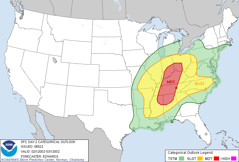
A major severe weather outbreak is in store later this afternoon
Be alert today as we will see some violent weather today. All this will be ending by mid evening. Warm front will be moving through putting us in the warm sector. That along with some sunshine will may things interesting. Highs will be above 70, increase dewpoints, and instablity will be produce supercells that should has long tracked tornadoes. This outbreak will be worse than couple of days beacause it's occuring at a later time frame and there is colder air behind the storm. Moderate risk still exist but it include the whole state. Main threat will be damage winds, large hail, and tornadoes. Time frame will be between 1p-7p. Have your weather radio with you today and take safety precautions. Much colder air tonight filter in. Lows in the mid 30's. Highs Saturday near 50.
Thursday, March 1, 2012
Severe weather threat Friday then a colder weekend with a chance of snow late this weekend
Subscribe to:
Posts (Atom)