
Monday, January 31, 2011
Highs Tuesday looks to be in the 40's in Louisville; 50's south of here
Minor changes to the short term forecast. Precipitation will be rain Tuesday. Highs will be in the mid 40's. East winds increasing throughout the day. Very windy Tuesday overnight- Wednesday. Winds gust up to 45-50mph. Precipitation will change rain to snow. Highs in the 20's Wednesday and Thursday. Here are the advisories out there tonight into Tuesday

Very windy conditions Wednesday; Potential snowstorm Friday night- Saturday
One of main weather concerns besides the heavy rain is the wind. Winds is expected to gust up to 45-50mph Wednesday am with snow. We will see blowing snows and light accumulations. N. Illinois will see 12-18" of snow. Some areas even more. Indianapolis looks at a crippling ice storm similar what we had few years ago here. A calmer weather pattern Thursday and Friday before our next winter storm potential out of the Gulf of Mexico Friday night and Saturday. Latest Japanesse model shows this nicely while gfs is too far south and east as in most cases 4 days out. Canadian has snow, Euro hinting something. Note Japanesse can be little overdone but it shows this going west.


Travel not recommended further north and west

What should we expect?
Today: Areas of morning freezing drizzle or rain then cloudy. High near 40.
Tonight: Cloudy with showers possible. Low 38
Tuesday: Heavier rain developing especially late. High 50.
Tuesday night: Heavy rain changing to snow; Very windy. Low 30. Light accumulations by morning.
Wednesday: Snow tapering to snow showers;Very windy. High 30. Light snow accumulations.
Long range forecast
I have in my winter forecast a milder Feburary. That won't be the case this year. We are stuck in the colder than normal pattern. Another snowy than normal month. We will see our big snow. It's just a matter of when. I expect at least 2 significant snows (6"or more) before the winter is out.
Next 7-10 days forecast
There is another storm the models are hinting Friday night- Saturday that could shift west and bring snow here. Another storm Monday - Tuesday time period that looks interesting. That will bring colder air behind it.
Saturday, January 29, 2011
Temperatures soar in the 50's for first time since New Years Day morning
Wow! Beautiful day today. Another mild day Sunday. Highs near 50. Cooler air and more clouds moves in later Sunday. A chance of light precipation Sunday night- Monday. Highs Monday in the upper 30's. Monday night- Tuesday I'm certain on preciptation type after studying the weather and looking at the latest computer forecast. Heavy rain at times Monday night - Tuesday. Highs Tuesday in the 40's. Tuesday overnight- Wednesday. Rain will turn to snow/wind. Snow heavy at times. We will see accumulatiions. How much? Too early to pin down. Look at the jma and gfs ensembles are suggesting Wednesday am. Heavy snow/wind. I believe it's handling the low level cold air therefore the track the storm further east than it's operational run of the gfs.


Another tricky forecast next week
There appears to be some issues in the models. Handling the low level cold air for our winter storm. It's unclear what precipitation type until the model get a handle of the amount of cold air with this winter storm. What I see is rain or freezing rain Monday night- Tuesday. Most of Monday is fine. Highs in the 30's Monday and Tuesday. Any precipitation type either rain/freezing rain we see Tuesday will change to all snow Wednesday. More updates throughout the weekend.
Friday, January 28, 2011
Milder weekend then return to below normal next week
Highs Saturday will be mid to upper 40's. Sunday now will be similar a bit warmer than I said this morning. Colder next week with our next precipitation. We may see light precipitation Sunday night-Monday. Rain/ice is the type of precipitation. Tuesday looks like rain to me changing to snow overnight Tuesday. Wednesday heavy snow/wind. JMA has a significant snow. Wow! This models has been showing this 2 days in a row. Canadian stay looks the same to far north. Euro is hanging to much back SW. Gfs is having problems will low level cold air.


One thing that stands to me is the high in the Rocky Mountains. 1050mb High. That will filer in low level cold air that the gfs doesn't see. It reminds me of 2004 setup. This will be a beast of storm.
Next clipper Saturday will stay notheast of us
A series of clipper system but it won't produce precipitation. One Sunday and one Sunday. Temperatures will be around 40 this weekend. Sunday being slightly cooler it appears than Saturday. Highs Saturday 42 and Sunday 40. Monday easterly winds and clouds will keep temperatures in the low to mid 30's. Then our next winter storm to affect the region Tuesday. Right now it looks like to bring here in Louisville ice to rain but further north ice. Whatever we get Tuesday will change to snow Wednesday. Just to note there are diffrences in the timing on this event. Canadian to me is too fast and further north. Euro, nogaps and gfs brings snow Wednesday. It's ensembles run of gfs and euro are similar. I likes what gfs ensembles shows switch precipitation to heavy snow. Winds are strong as well. We will keep on this over the weekend and see what happens before putting us under a significant storm threat.


Thursday, January 27, 2011
Clipper system to bring light snows tonight
Clipper system is schedule to bring another round of snow. Areas ne of the viewing area will see 1-3 of snow while Louisville will see up to about 1" snowand Central part of the state as well. We will keep an eye throughout the day with clipper. The track can alter at the last minute but right now that my thinking. Another clipper for Saturday. Some models vary on that but I think right now it will be stay north of us and bring warmer temperatures Saturday. Highs in the mid to upper 40's. Colder air comes Sunday behind it there a chance flurries. Highs in the 30's. Monday will awaiting our major winter storm to the west of us. I will wait until we get this clipper system in and out of here over the next couple of days before putting us under a significant winter storm threat for Tuesday- Wednesday time period. All models are suggesting this except Euro model and it's hangin too much energy back west as usual. Here is the Canadian for except. Tuesday evening very heavy snows in KY IN, WOW! A classic winter storm 996 mb low.
 Have a bless day!

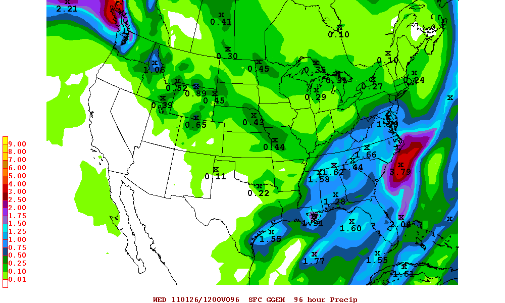
Wednesday, January 26, 2011
Forecast for Loisville held up
We are over 2" of snow so far and it's still snowing. E-town and just south of town is seeing the heaviest snows. Snowfall total will be up later. Now on to the weather. Highs today will be low 30's with snow ending by mid to late morning. Low tonight in the low to mid 20's. Highs Thursday mix of clouds. Highs in the mid 30's. Thursday night- Friday am more light snow. Light accumualation. Saturday will be windy mild. Temperatures will warm to the mid to upper 40's. Colder Sunday. Highs in the mid to upper 30's. Then on to our next potential big winter storm early next week. Here is Canadian ensembles and euro ensembles with our different than what the operational runs shows for Tuesday.


Tuesday, January 25, 2011
Forecast looks good to me
I won't be surprised if we exceed some of my forecast totals. Louisville is in good shape. Latest nam, ruc model, and nowcasting favors 2-3"of wet snow. It will be starting within a couple of hours and lasting thru the night into Wednesday am. That's folks and up to mother nature delivering the goods right or wrong. Next update will be total snow across the area and see how I did.
Snowfall forecast for tonight- Wednesday
Louisville 2-3"
Nashville, TN 5-6"
Memphis, TN 3"
Paducah,KY 2-4"
Lexington,KY 4"
Bowling Green 6"
E-town, KY 5"
Richmond,KY 5"
This will be a heavy wet snow that will down really fast.Areas that see large amounts of snow can see some power outages.So there is my breakdown.
Nashville, TN 5-6"
Memphis, TN 3"
Paducah,KY 2-4"
Lexington,KY 4"
Bowling Green 6"
E-town, KY 5"
Richmond,KY 5"
This will be a heavy wet snow that will down really fast.Areas that see large amounts of snow can see some power outages.So there is my breakdown.
Latest suggest to me this going little further north than the nam suggesting
Precipitation will make it to S. ILL and S. IN. Later this evening thru overnight. Temperatures will drop at this time. So Louisville is still the running to see snowfall overnight hours- Wednesday. 1-3" looks good for Louisville. Winter weather advisories should be out the way I see it and winter storm warning extended little further north and west. Cities of Lexington and Bowling Green are under a watch which will turn into a warning shortly.Where will heavy snow bands set up? W.KY, Central and Southern KY, East and SE will see the heaviest snows. W.KY 3-5", Central/So KY 6", East KY 8", SE KY 10". This is my best call right now.
Tricky forecast for late evening- Wednesday
Heaviest snows thru overnight thru Wednesday am heaviest will be W.TN, Middle TN, most of Western KY, and S.Central KY including E-Town, Bowling Green along 1-65. Louisville is on the edge. Will it move northward to reach Louisville. I'm sure but we will see light maybe moderate snows. Heaviest snows will be West central KY down to Memphis ( 3-5), Bowling Green, E-Town down to Nashville 1-65(5-8") and extreme SE and E.KY 8-10". This is a fun but challenging forecast. Elsewhere a tough calL NW KY 1-3" a sharp cut off further north between no snow and snow with this system.I will update forecast if needed later on. I will examine the afternoon runs and nowcast throughout the day.
Monday, January 24, 2011
Gfs and nam is slowly trending west on precipitation shield
I still believe the models aren't complete yet. It's better and better but we will see significant snows in Central KY, Southern KY, SW KY, Eastern KY as I have mentioned earlier today. 1-3 or 2-4" of snow in NW KY including Louisville. Cutoff of snows will be S. IN, ILL.So I do believe everyone in the state will see accumulations. More in the am. Goodnite. Lord's will I look over everything in the morning and give you my latest thoughts.
1-3 or 2-4 inches is what I expect in Louisville
No changes on the thinking Louisville or elsewhere pretty much 1-3 or 2-4 inch range. Central KY 3-5 or 4-6. ESE KY 6-8, extreme 8-12 isolated areas foot plus. Latest gfs 18z has tad more west from 12Z and it's not done. Local forecasters doesn't have any accumualation in the city of Louisville. I disagree totally and that will be changing. Winter storm watches late Tuesday and Wednesday for parts of Eastern KY. Will it shift NW tomorrow? More updates later this evening.

First call forecast on snow for Tuesday night- Wednesday
After looking at all afternoon data. My first call snowfall across the state. Keep in mind the track has yet to be determine. Very tough forecast. There is still room for a shift of the track to change. Here is my thinking. N and NW KY 1-3 or 2-4", Central KY 3-6, ESE 6-8", Extreme SE KY 8" or more.
Highs Tuesday will be 40 or near 40. Wednesday am around freeze. Highs around freezing. Thursday looks to be coldest of the week. Near 30. Warmer Friday before another shot of colder air drop in for the weekend. Another storm to start Feburary to track.
Highs Tuesday will be 40 or near 40. Wednesday am around freeze. Highs around freezing. Thursday looks to be coldest of the week. Near 30. Warmer Friday before another shot of colder air drop in for the weekend. Another storm to start Feburary to track.
Significant snows threat will be in Central and East/SE KY; Winter storm threat NW KY
Snow came through the area overnight. Only light amounts. Downgrade to winter storm threat for NW KY and significant snow threat I have shifted to south and east of the region. Sharp cut off of precip as you head into extreme S. IN and ILL. Tuesday night- Wednesday am snow west. Further east throughout the day Wednesday. First forecast call later today. American models are coming around trending further west. Canadian and ukmet is consistent on track. I like the looks of it.


Sunday, January 23, 2011
Light snow accumulations later evening thru Monday am
Late this evening thru Monday am. Light to moderate snow will fall across the our area. Up to 1" is expected. Be careful for the AM commute Monday. Lows in the low to mid 20's tonight. It will be diminish sometime Monday am leaving for rest of the day cloudy. Lows tonight in the low to mid 20's. Highs in the low to mid 30's. Even warmer. Highs in the upper 30's Tuesday before colder air and snow opportunity enters the forecast Tuesday evening and especially nightinto Wednesday am.
Some models continue west Tuesday evening- Wednesday storm
By the way light snow is in the forecast by Monday am. Not very much. Highs above freezing Monday and Tuesday. Temperatures will fall Tuesday evening. Snow will move in from SW to NE. Japanesse, Canadian , ukmet, euro precip is further west but little further east and gfs is further east Tuesday late evening -Wednesday. Precipitation should be all snow but a wet snow it appears to me. Here are some of those models data this afternoon. Canadian 3-6" in Louisville, JMA 3-6" in Louisville, and Ukmet same idea in Louisville.


Saturday, January 22, 2011
Below zero cold this morning... Significant snow threat still continue Tuesday-Wednesday
Here are some areas that saw below zero this morning am
Cincinnati -8
Frankfort, KY -4
Lexington, KY -2
Louisville, KY 6
Paducah, KY 16
Newest 0Z nam hot off the press. It has shifted further to the west. It has 3-6" Louisville, Foot of snow in Eastern KY, whole state getting significant snows. Wow! I still have a strong believe of seeing significant snows.


Significant snow threat Tuesday- Wednesday
I want to make things clear to the viewing that significant snow means a strong believe of 6"or more of snow. It doesn't means for sure we will see it. God controls the weather. Monday any snow we see will be light. Highs Monday above freezing. Tuesday will be above freezing as well but colder air, increasing winds, snow will move in. Wednesday snow will start to wind down. Here is the Japanesse, Canadian, Nogaps models. Japanesse has 8-10 of snow for Louisvile. Heavier further east. Canadian model has us getting 3-6 in Louisville and heavier east. Gfs is bias east. Euro is east. It has struggled some this year.


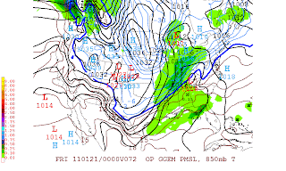
Friday, January 21, 2011
Winter storm threat and significant snow threat across the state is still alive next Monday -Wednesday
12Z this afternoon runs models has back from what it had 0Z this morning run. Models will have a better handle over the next few days but even though models hasn't got a good handle yet. I still bringing accumualating snows. Looks at the Canadian ensembles thru Tuesday am and Wednesday am precipitation amounts. Tuesday am around 3"of total snowfall and Wednesday am total snowfall around 4-5 of snow. This will increase as we get closer as the models get a better idea.


Significant snow threat Monday night- Wednesday
Snowfall totals from Thursday
Louisville 3.6"
Lexington 3.3"
Bowling Green 2"
Paducah 2.1
Home town of Memphis 2.0"
S.IN 5-6
Cincy 5.6"
Overall an accurate forecast. A last change to my snowfall forecast was a good call. 4-5 was the call for Louisville for example it was good. We were right in the mix.
Now on the weather. I put us under a significant snow threat for early next week now. After looking at the data and the support of my winter forecast of a significant snow this month. This is the way to go.
Here is nogaps, Canadian, euro, gfs 6Z(which now trying to develop a low with a negative tilt trough) for Tuesday evening- Wednesday.


 More updates lord's willing later today
Louisville 3.6"
Lexington 3.3"
Bowling Green 2"
Paducah 2.1
Home town of Memphis 2.0"
S.IN 5-6
Cincy 5.6"
Overall an accurate forecast. A last change to my snowfall forecast was a good call. 4-5 was the call for Louisville for example it was good. We were right in the mix.
Now on the weather. I put us under a significant snow threat for early next week now. After looking at the data and the support of my winter forecast of a significant snow this month. This is the way to go.
Here is nogaps, Canadian, euro, gfs 6Z(which now trying to develop a low with a negative tilt trough) for Tuesday evening- Wednesday.


Thursday, January 20, 2011
Snow totals so far and a look ahead
2-4 of snow across Indiana and Kentucky so far as of 5:00p. Louisville 2.1" so far. Another half inch or 1". Clearing skies tonight Low 12 and Friday. Friday 20. More clouds late Friday into Saturday. A few flurries or snow shower Saturday. Highs near 30. A break Sunday. More snow Monday and Tuesday next week. Look at the European ensembles Monday am and Tuesday am. Monday am Low in SE Arkansas and on Tuesday Low over W. KY We have to watch and see what end up happen on exact timing, exact track and strength of the storm.


Latest changes on snow amounts
I have lower snow totals little because of the speed of the storm and the heaviest of it will north of river. Heaviest in Loisville will fall this afternoon. It will diminish tonight. Lows will be in the lower teens. Highs for Friday 18. More clouds and light snow Satuday then looks to bring a coating of snow. A bigger storm Sunday night- Tuesday will have to monitor next over the weekend.
Louisville 4-5"
Cincy 5"
S.IN 6-7
Bowling Green 2-3
Paducah 2-3
Lexington 4"
Louisville 4-5"
Cincy 5"
S.IN 6-7
Bowling Green 2-3
Paducah 2-3
Lexington 4"
Wednesday, January 19, 2011
Winter storm warnings Thursday.Snowfall forecast is unchanged
Look at the previous post on snowfall. Snow will start in the morning but the heaviest will be in the afternoon. This will be a quick hitter. Highs Friday will be in the teens Friday. More light snow Saturday. Bigger storm Monday and Tuesday of next week. Will keep an eye on it.

No changes needed at this time
I like the going forecast. Highs will hold steady today. Low 30 tonight in the city. Holding around freezing mark with light snow moving in the morning becoming heavy throughout the day. Tapering off late evening or overnight. 6" of snow Louisville. 7-8 S. IN, 3-5 elsewhere. Snow ratios will increasing later afternoon/evening that something to note folks. Some light snow trying to move in this weekend and bigger storm early next week.
Tuesday, January 18, 2011
Snowfall forecast across the state including S. IN and Cincy Thursday
S. IN 7"
Cincy 5"
Louisville 6"
Lexington 4-5
Bowling Green 3"
Paducah 3-4"
This will be the largest snow we have seen so far this winter. Highs Wednesday will be in mid 30's and 32 Thursday and Friday 17. The weekend there looks to be some light snow trying to enter the forecast. Bigger storm early next week has my eyes.
Winter storm watch Thursday and Thursday night
Here is forecast call right now. I made no secret last night and early today. I believe Louisville see 6" Little more north. Snow will start Thursday morning and last all day. Snow will be heavy at times. Winding the down Thursday overnight.
Significant snows threat continue
At least 6" of snow is still the call. Canadian is still phased and along with the nam. Gfs still shows a decent snow and Euro is lone model hangin too much sw energy back. Details still needs to be study word of caution.
 Early next week Monday and Tuesday another storm looks to bring more snow opportunties and gfs agrees as well. Here is the Canadian ensembles.


Monday, January 17, 2011
Significant snow threat Thursday
Nam is phasing this storm for Thursday. Low pressure west of the Applachian Mountains. Heavy snow/wind across the Ohio Valley with at least 6 or more. Look at the 0Z Nam.

 Tuesday rain changing to snow Tuesday afternoon and evening. Up to an 1" or less of snow thru Wednesday early am. Flurries ending Wednesday am then remaining cloudy skies. Highs around freezing mark.


How much snow will see Thursday?
I don't know how much snow yet. I'm trying to see if this storm will phased to becoming a significant snow event. Right now Canadian is only model is coming around to that. Gfs doesn't phased it but still brings snowstorm here. Take a look at the diffrences.


Sunday, January 16, 2011
Rain changing to snow Tuesday by noon
Temperatures will drop quickly Tuesday through the day. Highs in the 40's dropping to near late in the day. Winds will pick up especially late Tuesday. Snow accumulations will be light in the order of 1-2. Snow will last through the evening. Heaviest snowfall will be noon thru early evening. Lighter snow and will continue to fall throughout the late evening and overnight. Winds will increase as well. Leftover flurries otherwise cloudy skies Wednesday. Highs near 30 Wednesday. Here is latest 18Zgfs ensembles run. It shows a nice burst of snow by noon Tuesday


Increasing moisture for Thursday's winter storm
Latest update on our next winter storm slated Thursday-Friday. Here is the gfs ensembles valid Thursday evening.It's moisture content increasing along high snow ratios as colder air moves Thursday night- Friday. We will watch the trends. Canadian ensembles moisture is increasing but not like this model. Euro is slow and it's hanging too back west as usual the model does.Nogaps looks really good. Wow! Here is nogaps below.


Wild week with the coldest air of the season so far slated for late in the week
First lets start today. Highs will be 30 today. Precipitation will hold off til late Monday so onset of wintry precipitation is out because temperatures will be too warm. Rain will move in later in the day. Rain will continue thru Tuesday morning then change to snow by afternoon. Light snow accumulation at best. Further east will see more no big snow for anyone with this one. Wednesday cloudy, windy, snow showers and flurries will linger especially early. Highs in the mid 20's. Here is gfs ensembles Tuesday early evening
 On to our next winter storm Thursday- Friday. This winter storm will have high snow ratios with. So we easily see a decent snow out of this. The questions is we don't how much moisture will have with storm. Our coldest air of the season with highs Friday in the teens. If we clear out Saturday am there is a shot at sub-zero. Here gfs ensembles Thursday


Saturday, January 15, 2011
Winter storm alert Thursday- Friday
I went ahead and declared a winter storm alert after looking at the afternoon runs today. I like the idea of a winter storm to affect the Ohio Valley starting Thursday. How much snow remainins to be seen? Canadian has a significant snows here with a inverted trough of low. Inverted trough of low pressure is notorious of brings heavy snows to our area.
 I still like our rain changing to snow forecast for Tuesday late morning. Monday will be mostly rain wintry mix on onset. Highs both days around 40. Tuesday highs will fall rapidly 40 Tuesday am down in the near 30. Winds will increase as colder air pour in. Light accumulations is likely. Here is Canadian ensenbles Tuesday am and Tuesday pm.


Subscribe to:
Posts (Atom)