Wednesday, February 29, 2012
Severe weather will be well south and east this afternoon; Active weather pattern continues
Severe weather has shifting south of Louisville and 1-64. Tornadoes and wind damage will be well south and east. More severe weather threat Friday and a clipper system sometime Sunday may bring snow. Timing is impossible to pin down and exact track this far out. It's still 4 days out. Clipper this time of year are the most complex and can be dangerous to forecast.
Will we see more severe weather this afternoon?
Look like our best chances south and east this afternoon but we still have a chance here. Still like mid 70's today. Tough to pinpoint. Whatever happens we will clearing tonight. Lows in the 40's Highs in the 60's Thursday. Friday highs in the mid 70's More risk of severe storms Friday. SPC has now put us under a slight risk.


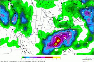
Tuesday, February 28, 2012
Severe weather risk overnight tonight and again tomorrow afternoon
A calm before the storm. Highs today will be in the low to mid 60's. Lows will be only be in the 50's overnight. Rising dewpoints and showers and t-storms becoming severe by morning. A big boost in temperatures tomorrow with near record high temperatures. Highs in the mid 70's. Old record leap year 77. Wow! This will increase our storm development. Where this exactly setup tomorrow afternoon/early evening? Is still unknown. A break Thursday. Friday more showers/t-storms. This could become severe especially late Friday. Highs looks to warm into the mid 70's. Turning colder Saturday with a chance of lingering showers/t-storms. Most models are still indicating snow chance Sunday late into Monday. The timing been push back. After that it looks like it will quickly warm up.
Monday, February 27, 2012
Warm work ahead again then turning colder this weekend

Friday, February 24, 2012
Wind advisory today; may see a flurry later today
Temperatures will be falling through the 40's today. Winds gust over 40mph at times. This weekend will be chilly Saturday highs in the 40's and back into the 50's Sunday.
Thursday, February 23, 2012
Severe weather this evening/snow showers Friday 24 hours later
The best chances of severe weather will form between Southern IN down the Central including Louisville. Tornadoes are becoming more likely. Dewpoints his morning are in the 40's and will be increasing in the 50's. Winds will be gusty out ahead of the cold front. This will be quick hitter. Highs is still expected to make it to 70 or higher. Tomorrow pm snow showers around the region as temperatures turning colder. These snow showers will be heavy at times. It's hard to pinpoint exactly where it will fall at this time. Latest nam has some heavy snow showers falling in the Louisville area by 4pm. More on this tomorrow morning.
Wednesday, February 22, 2012
Severe weather risk may be increasing Thursday evening
Latest spc has shift the slight risk near our way. Highs today will be in the low to mid 60's today and Thursday in the low 70's. We may see storms overnight tonight ahead of a warm front. A deep low preesure and a cold front will be responsible for showers/t-storms. The track of the low is still up in the air but if it goes further north than we will see best chances here.
Tuesday, February 21, 2012
Near 70 Thursday
Winds could gust up tp 40mph this afternoon. Highs in the mid to upper 50's. Getting into the 60's Wednesday and believe it or not but close to 70 Thursday. Showers and t-storms are likely. SPC for now is keeping severe weather to the south but we have watch the trends. Much colder Friday with a chance of snow showers late in the day but warming up back up this weekend and early next week.

An active pattern as we head into to March.

An active pattern as we head into to March.
Saturday, February 18, 2012
What my thoughts at with this storm?
1) How far north will precipitation makes it? If it doesn't make far enough north here no rain/snow.
2) Snow won't stick unless it snows hard.
3)Best chances of sticking snow will be south and east of us. Heaviest snows will be Eastern KY.
2) Snow won't stick unless it snows hard.
3)Best chances of sticking snow will be south and east of us. Heaviest snows will be Eastern KY.
Highest chance of snow of significant snows looks to be Lexington, Frankfort, and down to Bowling Green,KY
Louisville is on the hot seat for significant snows. We are in a waiting game and see how this workout. This is very difficult forecast. Japanessee is still holding on the significant snow here. Other models are not. Tonight we will be fine. No snow. It will be rain starting Sunday am then changing to snow mid morning and thereafter. Temperatures will drop to the freezing marks or around and winds will increase. Stay tuned for the latest updates throughout today.
Friday, February 17, 2012
12Z Japanesse models has shift north and west on track and slowed arrival of our winter storm threat
Lets talk about the weather for Saturday weather. It will be beautiful day with highs in the mid to upper 50's. Clouds will increase as the day wears on following by rain overnight not snow. As we had into Sunday morning heavy rain will change to heavy wet snow from west to east as temperatures drop from upper 30's 7am to freezing mark to end the day. I like the latest idea of the Japanessee model and it makes sense given the temperatures and the pattern. American models and Canadian models has it further south. This storm is a similar setup of what we saw January 26, 2011 but stronger. We saw 2.3" of snow and last minute forecasters change from us seeing maybe a dusting to 2" of snow and our sharp cutoff of snow end up being about 40 miles north of here was further north than the models except the Japanesse model which was right from the beginning 3 days before that storm. Here the Japanessee model. It has the low north Alabama. Good enough track of snowstorm here throughout the day Sunday.


Thursday, February 16, 2012
New 0z Nam is bring a crushing blow all of Kentucky Sunday for snowfall
Look at the latest nam printout precipitation. This is not my forecast and this is not etched in stone.


Winter storm threat for the state Saturday overnight- Sunday
Latest 84 hours nam and 72 hour japanesse model( below) is in and it has all state of KY with accumulating snows on Sunday and heaviest snows 10-12"of wet snow in SE KY Wow! Louisville up to 3". This type of snow can knock can cause power outages. We are still little more than 2 days away and 1500 miles away so this will change. I believe this could shift further north. Time will tell. More updates later today.


Wednesday, February 15, 2012
Storm to watch on later this weekend
I'm made mentioned that a storm by late this week last week. Well models are starting to sniff out a storm that has my attention. This has potential to bring snow by Sunday am as colder air moves in. Track is critical. We will monitor this storm in the upcpming days. MJO (Maiden jullen oscillation expected to be at phase 2 which bring cold weather in the Ohio Valley. NAO and AO looks to be postive which means signifies milder overall this weekend. So I can see a cold/snow over the Ohio Valley. Latest NAM 84 HOURS which is just within short term range is develop a storm south but this will change as we get closer.


Monday, February 13, 2012
1-2" snowfall Northern Ky up to Central IN
This is a late evening/ overnight event. AM Rush hour will be problematic. We will a transition to little rain in the am before ending. Whatever accumulation we see will occur before we end as little rain. Lows temperatures tonight will be 32. Rising in the am and through the day to 40 degrees. Warm up Wednesday and Thursday. Thursday we have another storm that go to the Lakes and bring heavy rains Thursday. Highs may get into the 50''s. Cool down this weekend. Some models has a storm I talk about last week for the end of the week but it keeping south right now.
Sunday, February 12, 2012
Snow developing late Monday- early Tuesday now
I've pushed the timing of the snow arrival as early as early evening. Main snows will be the overnight hours. Latest Nam is printout over.10 of precipitation. Therefore if it's all snow which I expect it to be then at least 1'' of accumulation. More updates tomorrow.
Saturday, February 11, 2012
First snow bust this year but another opportunity to get the next snowt right
Hey guys! Another bust in the snow forecast but we have more snow on the way. Lets start with lows tonight. We shoyld see lows between 10-14. Highs for Sunday 32. Sunny winds not as gusty. Lows Monday lows near 15. Highs Monday Mid 37 Increasing clouds. Monday night. Snow developing after 1am. Low 30. Snow accumulation 1-3" as early call. We will narrow this down as we get closer. Stay tuned. Models all agree on snow. Who will see the heaviest snow. It's impossible to pin down but models has west of 1-65 has heaviest right now.
Friday, February 10, 2012
Bigger break early evening before more snows thru the ovenight hours
We in a lull in the action while as I'm writing. Snow tonight will be coming from N. ILL and N.IN from an arctic front that will bring the coldest air of the season so far. I said last post that overnight hours thru Saturday am to watch out. This is expected to bring our accumulating snows as temperatures take a tumble overnight into Saturday am.
Snowfall forecast
Heaviest snows looks to be to our north of the river. Up to 2". Up to 1-2" 1-64 and points east. Most of accumulating snows will be overnight thru mid morning Saturday as temperatures drop. Traveling will be more of issue. Lows will drop in the low 20's and falling. Highs occuring early am. Coldest night of year Saturday night. At least 10 degrees but if we clear enough in the single digits.
Thursday, February 9, 2012
Prelim. snowfall call up to 2" of snow in Louisville
Latest nam has 4 rounds of snowfall. I lile it suggests. #1 early afternoon ( 1p-4pm) Moderate to heavy band of snow. #2 behind the front steady band of snow moves in early to mid evening 6p-9p. #3 Late evening and overnight 11pm-2am. More steady band of snow moderate to heavy at times. This looks to be our heaviest round snow. #4 daybreak thru mid morning snow showers. This will bring additional accumulations. Highs in the upper 30's. Temperatures looks to drop into the teens as the day wears on Saturday and hold there. Wind chills 0 to 5. If we clear out enough Saturday night lows should get below 10 degrees. Highs near 30 Sunday. Monday Highs in the low to mid 30's Increasing clouds. Latest suggest snow chance Monday night and Tuesday. We keep track of this.
Models keeping this all snow Friday afternoon
Latest gfs models has this all snow beginning after 1pm. Here is the latest snowfall forecast from gfs. It's showing up 2" of snow in Northern KY and Southern IN including Louisville and Up to 3" Indy. Rest of the state up to 1". This is not my forecast. I'm plan on issuing tonight or tomorrow am but this won't be a big snow. Right now I would say 1-3" stripe will a good range across the snow areas.


Snow accumulations Friday especiallly Friday night
Snow may start as early as noon tomorrow. It may mix in with rain before it switch to all snow early evening. Highs near 40 now. Snow accumulation to deal. Saturday highs will fall through the 20's Windy. Sunday am morning lows will drop 10 (lower if we see snow accumulations. Sunday highs around 30. Monday low to mid 30's. Watch out for wintry precipitation Monday night- Tuesday.
Wednesday, February 8, 2012
Snow chances are increasing Friday night/Sat AM
Highs Thursday will be in the low 40's and same Friday before rain moves in Friday afternoon. Cold front will pass through early evening changing rain to snow. Winds will increase Friday evening and turning dropping fast. Snow will continue thru night. We will deal with snow accumulations. Most models are holding on to snow thru Sat am. I'm not ready to extend that far. Need more time. Highs on Saturday will be very cold and windy. Colder than my last update. Highs in the 20's. Wind chills in the single digit. Sunday will try to get into the low 30's. Early next week looking more interesting with more clouds and winrty precipitation but what form. More on that another time. Active weather pattern shape for next week. Here are various computer models for Friday evening/ Sat am snow chances.


Next storm Friday looks to be light rain to start changing to light snow
All the models are suggesting this. Timing is not 100% certain. Most models develop precipitation in the afternoon. Friday highs may reach the low 40's then temperatures really tank overnight Friday into Saturday. Here is the following models. You can see the transition to snow around 6-7pm just to our along the river. 534 thickness line dash blue along the river. A cold Saturday. Highs in the low 30's. Lows in the teens Sunday am. Lowest temperatures we have seen so far is 17. We may challenge that Sunday am. An active pattern next week. We have cold air available could see a snowstorm later next week. We will see.


Tuesday, February 7, 2012
Last call on the latest snow
No changes really. Snow on the move daybreak from near Indy down 1-65 south to E-town moving points east. Up to 1 on average. Some areas seeing more than 1". Low tonight around freezing so some slicks spot for some people.
Up to 1" on average may see more snow 1-64, 1-75, and 1-71 Louisville and Lexington
It's is chance that areas from Louisville to Lexington and Louisville to near Cincy may see more than 1". Temperatures looks to be above freezing mark. It will be a wet sloppy snow on the grassy and metal objects. Gfs has more of my support.


Monday, February 6, 2012
4-9am looks to be timing of snow Wednesday am
Latest nam have the heaviest snows along 1-71 Louisville to Cincy. Gfs agrees as well Light accumulation mainly on the grass. Models has accumulations 1-2". Temperatures on this model are above freezing but if we drop freezing or below we will see bigger problems Wednesday am. Stay tuned for more updates.

Afternoon runs of the UKMET, Canadian, jma are showing light snow Wednesday daybreak
Here is the latest runs of the models. It's colder enough for light snow Wednesday am. Moisture are increasing from yesterday. We will keep an eye on this. This will be a minor event though if we see snow. GFS has more rain warmer. Timing is still an issue with me. We shall see.


light snow/light rain chance comes Wednesday
Highs 50 or better net few days. Light snow chances are in the forecast comes Wednesday. Timing is still issues and need to monitor. Temperatures are questionable has well. We will continue to look at model data today and tomorrow on this. This weekend is looking cold. More on that later.
Wednesday, February 1, 2012
Models are hinting changes to pattern 2nd half of Feburary?????
Look at the mjo which looks another factor of why we been warm. We need it to a 8 which means cold and stormy in te East. AO has been another factor but it's negative now. PNA is postive, NAO is neutral to postive. Look like March and April should be colder and stormy pattern.


Subscribe to:
Posts (Atom)