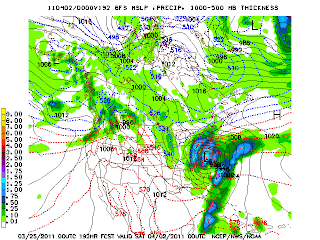
Sunday, March 27, 2011
More snow to start the week
Snow set tonight looks Louisville and point south. These areas looks to see a 1" or less. Lows will be 30 tonight. Highs will be cold this week. More chances wintry weather throughout the week. Tuesday late thru Wednesday AM and April Fool's Day. We have to watch each storm during the week.
Saturday, March 26, 2011
Couple of inches or so of snow tonight; More snow possible Sunday overnight- Monday early am
Heavy snows will be Louisville and points north. Louisville may see 2-3". More than 3'' is possible in some parts of the metro and north. Some 4" or more within 30 or miles of here are possible. This will be out of here before dawn Sunday am. Highs will be near 40 Sunday. We have to track are next snow showing up more on the models Sunday overnight- Monday am. More on that after church after looking over the data. After that winter still will be hangin on. More snow opportunities continues.
Tough forecast tonight
Gfs has us seeing 3-4'' in Louisville and 4" or more just north of Louisville. It has the heaviest snows just north of here. Nam has in E-town seeing heaviest 4" or more. Hpc also put us under a slight risk of 4" of snow tonight. Here is the Nws Service forecast. I has is seeing 1-2" of snow. I'm still saying around 2". We have to watch to see where exactly the heaviest snow bands form and when it start snowing. That will be the key tonight. More later.


Friday, March 25, 2011
Snow Saurday overnight ending Sunday am 7am
Looking now at 0Z gfs is is colder as well. First call for snowfall 2" or so Louisville metro. 3" or more near Louisville.
Things to watch for Saturday night- Sunday early am
1. Snow transition from rain/sleet.Will we see snow right before midnight instead of after midnight
2. Winds increasing from NE.
3. Where will the heavy snows bands set up Louisville or outside of Louisville?
4 Temperatures expected to fall to 30 Sunday am. Snow will be diminish by 6-7am.
5. Few slicks spots but no major trouble.
0Z Nam is shifting south; Snow along and just north of 1-64
Latest models is trending little colder and further south. It has couple of inches of heavy, wet, snow here.


Snowfall from nam Saturday overnight- Sunday am
Nam has 2-3'' snow in Louisville. 3'' or more inches of snow north of here. Look at the nam


Along 1-70 between St.Louis and Indy to 1-64 will see accumulating snows Saturday night thru Sunday am?
Snow accumulations Saturday overnight - Sunday am. Highs Saturday will be low 40's. Falling into the 30's in the evening as it start as rain changing to sleet then to snow after midnight. Winds will pick as well out of the east. Snow accumulating genreally 1-3" across the area. Some may see 4" or more that will be north of us. Low will be 30 Sunday am. So slick spots on your way to church services Sunday am. More updates as time goes on.
Rain later today then snow early Sunday am
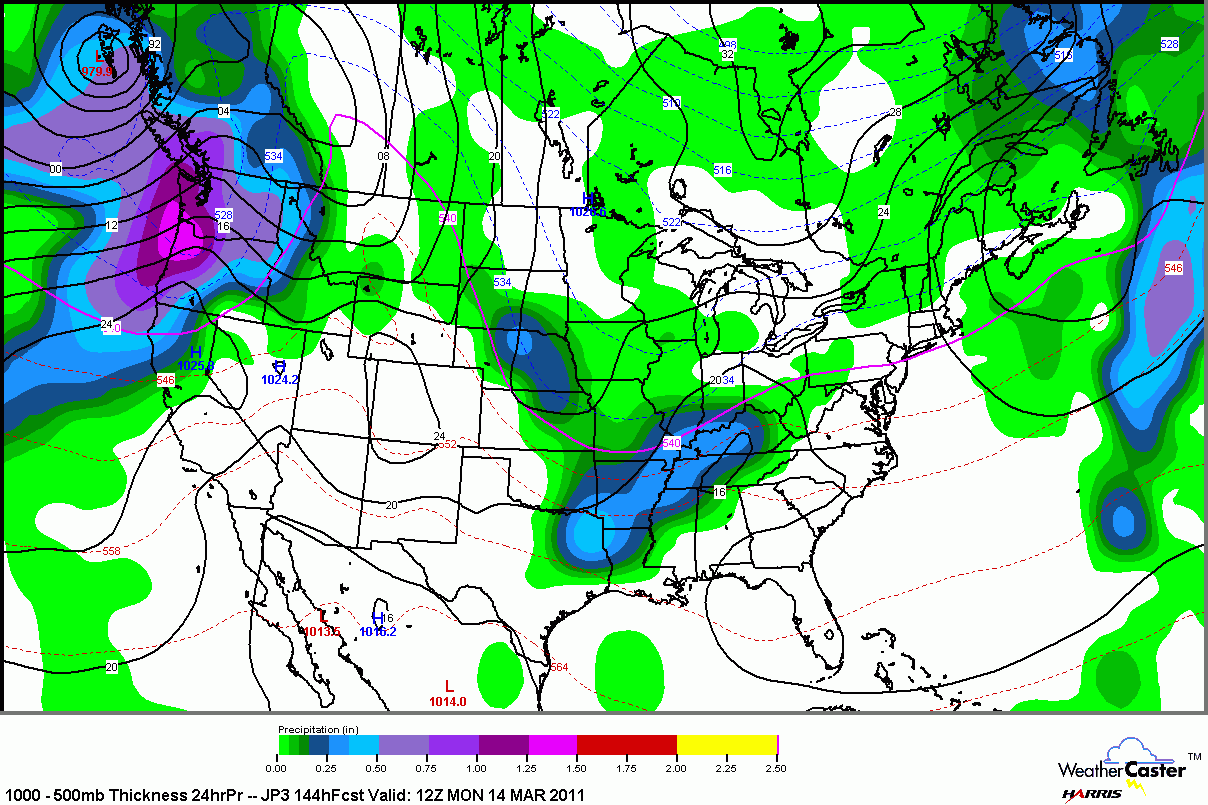
Highs will not warm that much. Cloudy and cold day again.Rain will move in from west to east. Most of Saturday will dry. Saturday night will see rain change to snow aslow moves east of us and colder air rushes in. Highs will stay in the 30's Sunday. Look at the models for April fool's Day next Friday April 1st and nam model for Sunday am. It showing opportunities snow. April fools is bringing a bigger storm. We have to continue to watch these feature. There looks to be more snow opprtunities after these features April 5th-10th time frame.


Thursday, March 24, 2011
Colder weather ahead; Chances of wintry in our near future
Today highs will drop from 47 currently as I WRITE through the 40's today. AM showeer this morning and reamaining cloudy. Clouds try to break up tonight. Some sun tomorrow. Highs in the mid 40's. Rain looks to hold off now until late Saturday. Highs looks to be low to mid 40s. Sunday am even colder. Snuday am models is trying to bring wintry weather Sunday am with a low to the south. Highs in the 30's. Early next week looks cold still. Highs in the 40's. Our snow next week looks iffy right now. More on that later today. A chance does persist even though the models has back off right now.
Wednesday, March 23, 2011
Moderate risk of severe to our east for the potential for tornadoes
Highs today is forecasted now to be in the mid 70's. Severe weather threat will be damaging winds, torrential rains, and large hail is the threat across Louisville. East will be a increasing threat of rornadoes. Chiller weather will be here the rest of the week. Highs mid to upper 40's Thursday and Friday. Saturday in the mid 40's rain. Sunday mid 40's and falling. A chance of rain early. Monday 40 cloudy. We have to watch Monday night into Tuesday with a potent storm to bring rain to snow . More on that later today.
Tuesday, March 22, 2011
T-storms Wednesday; Few storms may be strong to severe; Cold/wer rest of the week; Rain/snow next week
Main threat will damaging winds and some hail. Worst of severe looks to be east at this time. Much chillier air for the remaining of the week. Highs will be in the 40's. More rain again Friday night and Saturday. A cold rain. Sunday now looks dry but cold. Another storm which looks to bring our next rain to snow comes Monday late into Monday night and Tuesday. Rain changing to snow; Winds looks to be increasing throughout the day Tuesday. We have to watch this storm. It has interesting look to it. We have to talk about snow and cold for a while.Look at Euro model.


Monday, March 21, 2011
Record high temperatures likely Tuesday
If we see the same amount of sunshine or more. Highs tempratures will be in the upper 80's. All time record high for Mach is 88 back in early 1900's. We should be at least close tomorrow. I didn't update this morning. I've been resting and taking some time off. Severe storms risk Wednesday. Look at the latest map.
 Chilly temperatures for rest of the week. Highs in the 40's to near 50 into Saturday. More rain Saturday with storm #2 . Sunday and Monday colder air with a lingering showers Sunday.
Storm # 3 March 29 time period. Look what gfs has rain/snow nearby. Late last week I had March 30th for possible snow.

If that wasn't enough for good measure. Gfs shows a bigger storm in the east for April Fool's Day April 1st. This couild bring snow opportunity as well. We wil havel watch trends. This certainly fit the pattern I been alluding to. I made any secret of spring snow and a deep freeze as we haead into April. March 2007 saw 85 degrees on 24th and 2 weeks later we saw snow showers upper 30's for highs and record low of 25. Interesting pattern.

Friday, March 18, 2011
80's and snow flakes the same week next week; Wild weather pattern coming up
Weekend forecast Saturday and Sunday
Becoming Partly sunny, breezy,and cooler. Highs around 60.
Saturday night: Increasing clouds; Chance of rain by daybreak. Low 48.
Sunday: AM showers; PM sun Highs 65-69.
Early next week. A slight chance of rain early Monday and Tuesday otherwise partly cloudy and very warm. Highs near 80 Monday and low 80's Tuesday.
Mid week storm could bring doesn't look as impressive but still should bring showers/t-storms.
Late week: Cold with rain & snow showers Thursday.
Long range: Here is gfs model for March 30. It what is showing what I been saying snow. Will be bring snow accumulation. Even the 1st week of April looks interesting as well b/t 4th-7th. We are any means done with snow.

Wednesday, March 16, 2011
A cap in the warm up this weekend with cooler air Saturday and showers&t-storms Sunday
Highs in the 70's over next few days. Highs Thursday and Friday in the mid to upper 70's both days. Cooler this weekend. Not as cool as early in the week. Only near 60 both days. Rain ends Saturday am and returns for Sunday. May have chances into Monday but Tuesday and Wednesday especially will warm back into the 70's. No 80's yet. Late next week into the following weekend still looks interesting as far as cold and snow showers. Supports from Canadian and gfs models. Have a great evening.
Tuesday, March 15, 2011
Our first taste of spring over the next 7 days with highs well into the 70's and a day even reaching around 80 next week
Increasing threat of severe weather will increasing week with rapidly warm temperatures. We don't see 80's too often in March here. Last time we saw 80's was 2007. The following April we saw record low temperatures and snow showers in early April. We will start our huge warm up Thursday. More rain and storms comes Friday evening and overnight. Saturday looks great with highs in the mid 60's with a front passing through the area. It will return back as a warm front Saturday night into early Sunday bringing some rain/t-storms but temperatures will try warm into the 70's in the afternoon. Monday and Tuesday will be either near 80 and around 80. Severe weather threat returns mid week next week. A real nice cold shot bring a chance rain to snow showers Thursday 24th of March showing up in long range models. Highs in the 30's late next week. A big swing in temperatures.
Monday, March 14, 2011
An active cool spring second half of spring and possibly a mild summer
A soggy day today. Highs around 40. High reaching 50 or so Tuesday. A nice warm up later in the week. More rain Friday night. Early next week temperatures will warm even more with a passage of a warm front. High near 80. Wow! We have to watch for severe storms early next week as well. Still looking for a cold shot to end the month. How cold is looking uncertain to me. We will watch the trends. Rest of the spring will be colder than normal looking forward. An active severe weather as well. Looking to the summer so far I'm starting to think right now we may to have a mild summer.
Saturday, March 12, 2011
Spring fever will return
This weekend weather will improved. Highs today in the mid to upper 60's. A sensational Saturday is in store. Sunday cooler but looks fine. Monday looks to drop in the 40's with rain opportunities. Rain chances may linger through Wednesday am. A huge warm up Thursday. Highs may reach low 70's. Friday a chance of rain but still very warm. Warm weather looks to last now until the last week of March into April. Chances of snow and cold will return. We still have cold weather in Canadian.
Friday, March 11, 2011
Weekend forecast Saturday is pick of the weekend
Weekend weather forecast:
Today: Clearing highs in the upper 40's.
Tonight: Clear. Low low 40's and holding steady and slowly rising toward morning.
Saturday: Partly sunny with gusty winds. Winds will gust up to 30mph+.Highs in the low 60's.
Saturday night: Mostly cloudy; Slight chance of rain/t-storm overnight. Lows mid to upper 40's.
Sunday: Good chc of rain. Highs in the 40's. Colder.
We still have to watch Monday for another storm to bring rain to snow. Highs in the upper 30's.
The rest of next week will warm up into the 60's. It will try to get colder the week of 20th.
Thursday, March 10, 2011
Showers today; Too warm for snow; Tonight litle snow farther east
Highs today will be in the low 43 and falling into the upper 30's. Friday in the upper 40's. Saturday in the around 60. Sunday and Monday colder. Still differnces in the models Monday. More update later Lord's will. Mid to later part of next week highs trying to get in the 60's before a nice cold shot for next weekend. Late month into the 1st half of April we have to watch for continue stormy weather and yes snow.
Wednesday, March 9, 2011
A slushy accumulations Thursday especially east part of the state
Heaviest snows looks to be set up eastern half of the state. We will be above freezing mark Thursday so it will have to snow hard to stick on the grass. We will see snow showers across the state. Highs will occur early. Daytime temperatures looks be in the upper 30 early fall to mid 30's. Winds will be gusty. Temperatures will warm Saturday close to 60. Early next week temperatures goes back down. A roller coaster ride over next 5 days. Precipitation mischief early next week to watch.
Long range looks intersting
No changes in the forecast in the short term. Early next week we have to watch a system coming out rom the west to bring us light snow Monday with cold air in place. There are alot of diffrences in the modeling this morning. Gfs doesn't see it anymore, Euro is holding back this piece to me, Canadian is little to fast but still bring light snow Monday. All has problems. Temperatures moderate some through next week. Next weekend colder air returns again and could bring a chance of snow. It's looks to be the 23-24th time period we may have to watch for snow. Long range is start to show this morning. A chunck of cold air in Canada will try to unleash. Late March and 1st part of April.
Tuesday, March 8, 2011
Spring forward this weekend
We still have heavy rain tonight & overnight. About 1"-1:50". It moves out in the morning then more showers/t-storms in the evening. Highs around 60 Wednesday. Temperatures will hold in the 30's Thursday and will bring snow showers. It will be hard to accumulate. If it comes down very hard it has a chance but that's only way. It will on the grassy areas. Areas the cool faster. It will be windy. Temperatures will warm in the 40's Friday and 50's Saturday. Showers maybe possible Saturday. Colder early next week. We have an interesting setup Monday of next week to watch. Canadian, gfs, Japaneesse models sees a developing low to the south by Monday. With cold air in place. Light snow is certainly possible. Not a warm week next week either. Remember to set clocks forward an hour Saturday night. Spring forward.


Flood watch east of us; Snow showers Thursday; No warm weather anytime soon
1"maybe 2" of rain is expected. Flood watch further east in the state at this time. Be careful out there tonight. Temperatures today will get into the 50's. Tonight near 50. Upper 50's Wednesday. Thursday highs will top at 40 early am then falling into the 30's with snow showers. It will be quite windy. Friday in the 40's. More showers enter in the forecast Saturday with another storm. It will be windy out of ahead of it and behind it. Few lingering snow showers Sunday am possible. Early next week will be chilly again. Temperatures will try moderate some through middle of next week before another storm bring another round of heavy rain to snow around 17th-18th or so. It's a chance we may not see 70 this month.
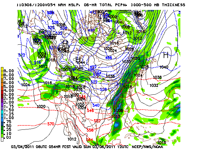
Sunday, March 6, 2011
Tuesday night- Wednesday am heavy rains; Another developing low to bring opportunity for rain to snow Thursday
Another heavy rainmaker is due again Tuesday night through Wednesday. More rain changing to snow with another wave of low perssure that may be cutoff from the main flow and becomenegative tilt. Look at the Canadian model late Thursday. Gfs and nogaps doesn't see this. Euro looks better. It's more progressive. We have watch the trends over the next few days. After all this is March madness. Weather can change rapidly.


Saturday, March 5, 2011
Quiet weather Sun- Tuesday then next heavy rainmaker affect us starting Tuesday night
After some early am morning light snow. Sunday is looking good. Highs in the 40's. How far into the 40's depends on amount of sun. Monday will reach around 50 with alot of sunshine. Tuesday increase clouds. Rain wil start to move in from west to east later in the day.Heavy rain spreads across the area Tuesday night and Tuesday overnight. Heavy rains continue through Wednesday. Highs staying into the 50's. Thursday we see diffrences in the models. Canadian is forming a wave of low pressure and a negative tilt trough of low pressure. This solution will bring rain to snow Thursday later in the day. Snow continues into the Friday. Gfs and rest of models is progressive and bring cold air in and out. Thursday it bring snow showers with highs into the 30's. Warmng up Friday. We will watch the trends over the next few days. I mentioned few days of a possible wave of low pressure Thursday. This is still on the table. Take a look.


Flood watch today then light snow early Sunday am
Flood watch thru this evening. Rainfall between 1-2" Some areas may see 3" Colder air will move in overnight. Light snow will fly but don't be surprise to see dusting of snow accumulation Sunday am. Temperatures will be cold. Highs around 40. Temperatures will rebound back into the 60's by mid of next week out of ahead of more heavy rains. Snow showers and falling temperatures on Thursday. Most models are showing this. Snow showers may last thru Friday per Canadian model. I'm supprting thru Friday am at least right now. Forecast gets very muddy 7-14 days. There is diifrences in the models whether will see colder air or not. Timing of each storm system has well. Regardless the end of the month and early April as mentioned I'm looking for colder the normal temperatures and more snow opportunities.
Friday, March 4, 2011
Flood watch for Saturday
1-2" of rain is expected yet again. This still to me to end as light snow. Rain will stay north and west today. Main rains will be here Saturday am. Highs Saturday will be in the 50's. Sunday am lows will low to mid 30's. High reach 40 or near. Here is Canadian and nam showing the low tracking west of Applachian Sunday am. This will not be a big snow but we will have to watch this.

 Next Wednesday another big rain maker again.Thursday rain changing to snow showers all models showing. Latest doesn't now show the second low. If we develops a second low we will see a snowstorm late next week. Forecast is up in the air right now

Wednesday, March 2, 2011
Snow talk and long range discussion
Here are our chances of snow:
- Saturday overnight into Sunday am. Another wave of low pressure.
- Next Thursday models are showing another low pressure Euro is west of Applachians and gfs is east of the models. Here our the model diffrences. This could turn out to be a nice storm.
- Late March and early April there are signs of very cold air. We still have lot of cold air in Canada and it has to go somewhere. Also with cold air is snow chaances as well. So winter is not over and we see at least one really good snow before we can move on to spring weather.


Heavy rain/storm/some flooding Friday thru Saturday
Highs today will be in the around 60's. A very pleasnt day. Another big storm system will be getting it's act together by Friday. Another impressive rainfall event. 1-2+ is expected. By Sunday morning some light snows are possible. Latest forecast for early to middle of next week. Highs in the lower 40's tops Sunday. Monday near 50. Tuesday makng a run at in the 60's and next Wednesday another big storm to bring heavy rain/t-storms. Highs in the 60's. A big cold shot behind the front late next week with a chance of snow showers.
Tuesday, March 1, 2011
Very heavy rains/t-storms with more flooding Friday - Saturday then snow showers Sunday
A quiet weather pattern for next 10 days. A battle in the weather pattern and a stormy pattern. Temperatures will be in the low to mid 50's today and into the 60's Wednesday- Saturday. Friday and Saturday more heavy rains/t-storms. Sunday will be down to near 40 with a chance of snow showers. Next Monday and Tuesday highs in the 40's, Wednesday back in the 50's More heavy rains for next Tuesday- Wednesday then snow showers Thursday. Forecast trends in the next 10 days of March. We still have watch within the next 1-3 weeks for snowstorm to brew. This time of year models always doesn;t see this until last minute
Subscribe to:
Posts (Atom)