
Monday, February 28, 2011
Late season snowstorm potential Sunday thru Monday am
Quick update. I'm just showing what this pattern can do as I had no secret. Eventually I believe we haven't seen the last of winter. Next 2-3 weeks will be breath taking of a weather pattern. An active pattern is in the works. A prime example is the Canadian. WOW! Snowstorm Sunday. A very dynamic storm with 996-998 mb low. It will genrate it's own cold air. Heavy wet snows across the state and nice track. This will be challenging type storm. Euro has a similar look. Gfs is an outlyer at this point.

Severe t-storms are moving through. Tracking our potential snow later this weekend
Heavy rains, wind, severe storms, and some tornadoes will be the rule across the state throughout the 1st half of the day. Weather will improve later today across the state from west to east. Tornado watch is in effect until later mid morning and further east until 1pm. Temperatures will drop this afternoon and get down around 30 Tuesday am. A quiet rest of the week until we approach the weekend. Another storm has my attention already. Rain will move in Friday night intohe day Saturday and bring another round of heavy rain/t-storms. It's behind the storm that has my interests. Colder air will move in Saturday night into Sunday and turn the rain to snow. It's developing a negative tilt trough of low pressure tracking along the Applachians or just west of it. That will be a good track for snows across Kentucky. All the foreign models see this. Gfs disagree is bias east. We will track this as the week wears on. Interesting setup the models are showing up though. Colder weather pattern next week with more snow in the works.


Sunday, February 27, 2011
1st moderate risk of severe storms of the season
Severe weather is on the way. Our 1st real severe weathr outbreak this season. Here are the following we have to be mindful of Monday.

We will keep an eye to the weather. Have your weater radios near for the latest weather information. I said last week that this storm concerns me and this is ending up holding up. Now mother Nature is to deliver whatever he want to bring.
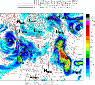
A long range look for next Sunday March 6th. We will have watch this trend. There is a chance of rain to snow scenrio. Latest Canadian, Nogaps show this is well. Even euro indicate this but I didn't include. Gfs is bias further east.

- Temperatures will continue to increasing this evening and overnight.
- Highs reaching 70 or near 70
- Warmth and potent low pressure storm will produce severe storms, flooding rains, and tornadoes.
- Winds gust up 50mph mph
- 1.50- 2.00" of rain
- Flood watch through Monday.

We will keep an eye to the weather. Have your weater radios near for the latest weather information. I said last week that this storm concerns me and this is ending up holding up. Now mother Nature is to deliver whatever he want to bring.
A long range look for next Sunday March 6th. We will have watch this trend. There is a chance of rain to snow scenrio. Latest Canadian, Nogaps show this is well. Even euro indicate this but I didn't include. Gfs is bias further east.


Saturday, February 26, 2011
Severe storms Monday
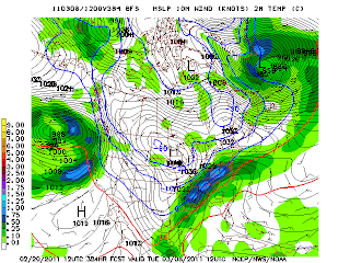
Diffrences in modeling as far as rainfall amounts thru Monday. Latest nam has 1" of rain and gfs 2" Highs will warm over next couple of days. 70 Monday. Severe weather Monday with damaging winds, flooding, and some tornadoes. Rain early Sunday. Highs in the 60's. Here is the severe risk for Monday.


Friday, February 25, 2011
Another more powerful storm for Sunday- Monday that has my attention
Storm Prediction has areas further west under a severe threat for Sunday that will be moving east Sunday overnight into Monday into Ohio Valley. Here the SPC map for Sunday Day 3. Rainfall amounts will be impressive again and flooding will be a even bigger issue. A growing concern that I track over the weekend. Stay tuned.


Thursday, February 24, 2011
Flood watch remains thru Friday am
Heavy rain throughout the day today. All of this will end by morning leaving to a colder day Friday. Saturday looks really good. It's Sunday especially Sunday evening thru Monday that will go downhill. Check my previous post on that. Long rainge next week. Most of next week looks really good to start March. Highs will from 40's Tuesday to close to 60's to 70 later next week. Tuesday will be coldest next week. Remember we are still early in the spring so therefore things can rapidly. We are not done with snow. At least 1 significant snow for it's all said and done.
Wednesday, February 23, 2011
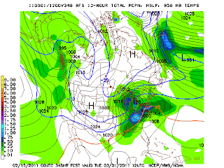
Nam continues with 3-5" of rain Central KY including Louisville.
Rainfall will be impressive. Nam has slightly shifted and now has most of the Kentucky seeing 3-5" of rain. Severe weather will be just to the south and SW of us. Diffrent story next week. Highs Friday will be in the 40's. Saturday 50's and Sunday& Monday 60's. Not as cold next week as I thought. More on that in the am.


2 major storms to affect us over the next 5 days
Sunday- Monday storm could be a major problem for us as far as flooding and severe storms. I'm honestly more concern with that storm. That shouldbe a stronger storm for one and two we will have already have seen significant rains from this storm tomorrow thru Friday am. 3-5" looks like a good bet across Kentucky. Models continue to show heaviest rains for Louisville. There is slight diffrences in the gfs and nam for far heaviest rains set up. That will be critical as far who exactly will see heaviest rains. Areas that see heaviest rain will see 3-5"of rain. Therefore Louisville is the running. Friday will be colder highs near 40. Sunday a break before more heavy brains Sunday. Heavy rain & Severe storms Sunday night into Monday has to be watch very carefully. I'm very impressive with this features models supports me well. There are diffrences in timing but powerful storm are showing up.
Flood watch Thursday and Thursday night
Impresive rainfall totals are really showing up on the models. I agree with this solution Heaviest rain looks to be from Paducah to Louisville. An axis of 3-5" of rain. This will cause some problems. Remember back in November we saw heavy rain that change the pattern in December. It will do so for March. Here is nam qpf amounts thru Fri.
 Another heavy rain/t-storm threat again Sunday and Monday. A powerful low pressure to watch. This will bring more heavy rains across the area. This will cause flooding.
March 10th long range models is showing an impressive amouns of moisture with a cold air mass. Wow! This is something we need to watch and keep an eye on. More than likely we will get hit before the winter is out.


March 10th long range models is showing an impressive amouns of moisture with a cold air mass. Wow! This is something we need to watch and keep an eye on. More than likely we will get hit before the winter is out.

Tuesday, February 22, 2011
Heavy rain Thursday- Friday am
A calm before the storm Wednesday. Heavy rains will affect the whole region starting Thursday thru Friday am. Rainfall will be very impressive across the region 2-4 of rain. Where will the heavy rains exactly be will hard to pinpoint. Here is the gfs ensemnbles rainfall forecast.
 More rain in the forecast again for early next week. A chance of severe weather. Highs in the 60's possible Monday. Here is the gfs for next Monday.


Monday, February 21, 2011
Significant Spring storm Thursday then back to winter in time for March
Rain for this evening and light rain/drizzle Tuesday. Highs in the low 40's. Warm up back into the 60's Thursday. With warmth and increasing winds, and stronger low tracking across the Ohio Valley. Watch out for heavy rains and possible evere storms. Here is gfs model for Thursday and Storm prediction Center threat for severe storms.

 Whatever happens we will see colder air for the weekend. Highs looks to be in the 40's.
Next week a change in the weather pattern looks to take hold. Here is what gfs for Tuesday March 1st. It's letting us know we are not done with snow. In fact I'm expected a return winter and snow threat around here.


Next week a change in the weather pattern looks to take hold. Here is what gfs for Tuesday March 1st. It's letting us know we are not done with snow. In fact I'm expected a return winter and snow threat around here.

Sunday, February 20, 2011
We are in for roller coaster ride over the next few weeks
A roller coaster ride it will be. From potentially seeing 70-72 tomorrow to 30's and few snow showers Tuesday am. Wednesday- Thursday will mild up out of ahead of big storm that will be a good soaking rain. Friday will be cold again but there are timing diffrence in one model that's the gfs. It has 50's with rain to snow showers. All the foreign modelsd has 30's snow showers. Next weekend another storm will be track this looks right now rain and/or snow system. Gfs developing a snow system for next Sunday.
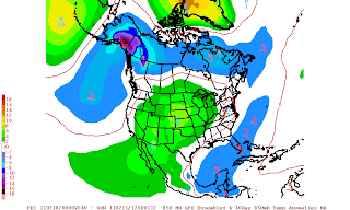
 Very cold March 1st half of March. We really watch for a potential significant vwinter storm. Look at the temperatures.


Friday, February 18, 2011
Active weather pattern that will set the stage to a very cold/snowy 1st week of March
No rain today. Highs holding in the mid 60's today. Cooler air works in tonight and Saturday. Highs only in the mid 50's. Sunday will feature increasing clouds and chance of showers later in the day or night as our first low passes to our north. Highs in the mid 60's. Winds will increase throughout the day. Monday will see a better chance of rain with a second low developing along the approaching front moving across the Ohio Valley. Highs getting into the 60's before it turns colder Monday night. A huge swing in temperatures with this one. Gfs ensembles for tues am has light snow early Tues am. Heaviest snows will be in Ohio toPennsylvania.
 Couple days later another storm to bring heavy rains Thurs/Fri time frame

 You see that colder air building in Canada towards the end of the month. It will build toward our area to end the month into March. Once it does it will be here to stay for a while.


Thursday, February 17, 2011
70's today enjoy then snow chances next week
Temperatures will soar into the 70's today. Rain will move in overnight tonight into Friday am. Not a all day rain. Highs in the mid 60's. Friday night cooling down into the mid to upper 30's. Highs near 60 Saturday a pleasnt Saturday. Saturday overnight some showers will move in and a windy day Sunday as temperatures soar into the upper 60's. Sunday and Monday more rain and colder air will begin later Monday with a area low pressure tracking south of us. Monday night- Tuesday am we have an opportunity at snow. Canadian shows this very well and we have watch this in the coming days.
 After more rain and milder temperatures late week. More snow opportunities next weekend. Gfs shows a snowstorm on 2-26 Saturday.


Wednesday, February 16, 2011
Spring fever continues
Highs today reach 70 and will do so tomorrow. A chance of showers overnight Thursday and Friday am. Saturday near 60. Sunday rain chances returns highs in the 60's. Monday another strong low will move through as the day wears bring rain.Looks what the euro ensembles brings by Tuesday am colder air and snow. We have to watch this.
 It looks to mild up out ahead of another storm next Wednesday night- Thursday time period. Colder air behind that. One of these storm will bring us a wintert storm event soon. I just can't bring my finger on it.


Tuesday, February 15, 2011
Active weather pattern over next few weeks
Hello folks. Happy Valentine Day. I took a little break. The weather been very nice and will continue to be nice today. Highs in the low to mid 50's. Increasing clouds late. A few showers tomorrow highs in the mid to upper 50's.Breezy day as well. High Thursday highs likely will get 70 now. Less clouds and showers staying north and west of us along with windy conditions temperatures will soar. Thursday night- Friday rain will move in along with windy conditions as the front pushes through. Saturday will be little cooler. Highs around 50. Early next week an intensfying low perssure system that looks to bring a chance of strong to severe t-storms and strong winds Monday. Highs well into the 60's. Back and forth temperatures trends next week. Here gfs for next Monday and powerful low pressure system about 990 mb in the Western Lakes. Lines of strong and severe storms we will have to watch. Winds gusting over 40mph.
 Our next winter storm to track between Feburary 28 and March 2nd to track then extreme cold behind this storm. We should be ready to track snow at time period.


Saturday, February 12, 2011
Clouds/ showers/breezy conditions should keep us from 70 late next week
I don't believe we will see 70 late next week but I do see few 60's. I believe 70 will be west of us into the Plains. Huge temperatures swing there. It got down well below zero in Oklahoma couple of days ago. Enjoy this milder weather next week because one of models are hinting a wintry potential as early as 20th or 21st. It also hints a storm as I mentioned for 23rd-25th time period. Therefore winter is slated to return for the last 10 days of the month of Feburary and more winter storms to track into the 1st half of March or so. I still do believe we will see 2 significant snows for it all set in done. 30'' of snow for this season is likely which could be the 1st 30" or more of snow since 1977-78 season. Last La'nina season we have seen 30" was 1950-51. At this time that year we was at about 20". This year little over 18". You see why I love our chances at 30". My winter forecast supports this well. I'm the only forecaster in town that forecast 30 this season. Have a bless weekend.
Friday, February 11, 2011
A break from the cold next week then return to winter the following week
Starting this weekend we will start our mild spell which will last little over a week before winter returns for last week Feburary and yes snow chances are showing up between 22nd- 25th of Feburary. Long range models are hinting this. Gfs and Euro. We keep an eye on this. In the meantime enjoy this spring like weather. I believe we will see 70 out of this mild spell late next week. Rain chances will increase the second half of the week next week as well. Have a wonderful and bless weekend.
Look at the gfs ensembles next Thursday and the following Tuesday. Big diffrences in temperatures b/t the two images.

 With moisture from the south we have to watch for snowstorm around this time period.
Look at the gfs ensembles next Thursday and the following Tuesday. Big diffrences in temperatures b/t the two images.
Thursday, February 10, 2011
Big warm this time next week
Last 20's for a while then we off to a milder trend for a while. Highs for the weekend will be low 40's on Saturday and well into the 50's Sunday. It will be windy. Chillier on Monday. Highs in the 40's. Snow showers will stay north and east of us. Second half of next week we will really going to see spring time weather. Highs in the 60's but chances of rain will be the price with it before next weekend starts. Chilly air behind the front to start next weekend will drop our temperatures the weekend of the 19th. Look at the flip today to this time next week. Thank you for stopping by at my blog and have a bless day.


Wednesday, February 9, 2011
Models are trending slightly north amd radar trends are matching up so forecast looks fine
Louisville should see around 1". Further north 1" or less. 2-4 south of 1-64.
Watch radar trend today to see how far north the snow goes.
Snow forecast remains the same for now. Look at the Friday overnight trends. A chance of flurries or light snow but right now mainly north. This is due to a clipper system. I have my eyes on that just in case in the coming days. It will be a windy weekend. Saturday will be in the 30's to near 40. Sunday well in the 50's. Monday am will be mild and windy out ahead ahead of another cold front which will drop temperatures later Monday. It could bring snow showers on he back side . Tuesday will be chilly. European shows this nicely.
 After this cool shot then a nice warm up the remaining part of next week. Highs getting in the 60's.

Tuesday, February 8, 2011
Snow forecast across the state of Wednesday
I held off talking about specifics this morning. I waiting til this afternoon. Looking at the forecast data and weather pattern. I now believe we see snow in Louisville but how far north snow shield will reach remains to be seen. The answer will be Wednesday. I'm expecting Louisville to up to 1" and along the river. South of 1-64 I'm expecting 2-4" of snow. Winter weather advisories are further south in Paducah viewing area and Bowling Green. Areas further south in Tennessee will see 3-6 of snow. Western Arkansas and Oklahoma, South Kansas will see some 12"+ of snow but all areas will see 10" of snow. If I have changes I update them.
Windy and warm weekend
First we have our cold weather to deal with this week. Highs today will be in the upper 20's. Highs Wednesday will be in the mid 20's with more clouds throughout the day. Slight chance of snow late Wednesday but most of the snow will be south of here Then temperatures will start it's upward threat starting Friday. Friday will be in the 30's. A windy and warm weekend. Highs in the 40's and 50's. 60 next Monday with a chance of showers/wind. Next week looks let gfs ensembles next week. temperatures are above normal across the country. Coldest air lock in Canadian. A break from the coldest of the cold.

Monday, February 7, 2011
Milder pattern next couple of weeks then a cold March and April
Snow will tapering off later this evening follow by colder air. No big deal on the snows. 1" or less at best. Highs in the 20's for next couple of days. Mid week storm looks to stay mainly south. A change in the pattrern over the weekend and next week overall. Good news for cold and snow lovers.A La'Nina is still in progress. Therefore winter is not over. La' nina usually bring later springs around here. So end game favors cold/ snowy pattern for March. La' Ninas of 1996, 2008, 1971 had snowy March. Also April was chilly in the Eastern US. So I believe we will see a cold March and April across the Ohio Valley. Enjoy your day.
Sunday, February 6, 2011
Winter weather advisory with moderate to heavy wet snow for Monday
No changes to my overall idea of a general 2-4" snow across western and north central KY. That includes Louisville. I don't know for sure yet where the heaviest snows will form but anywhere in this areas will see up to 4" of snow. Temperatures will start in the mid 30's Monday and will fall throughout the day to 30. Winds will gust up to 30mph and higher in the afternoon. That means snow will be blowing around. Heaviest snow will fall from mid morning through the afternoon Monday. It will start to taper off to flurries in the evening.
The mid week storm
Most models has shift even further south but we will see over the next couple of days where this storm could track.
Nam and gfs is little further north than previouly. We will see if we can get nw shift of the track.
The mid week storm
Most models has shift even further south but we will see over the next couple of days where this storm could track.
Nam and gfs is little further north than previouly. We will see if we can get nw shift of the track.
Saturday, February 5, 2011
Snowy and cold week
Rain/snow Sunday night- Monday
Sunday night- Monday: I believe now we will see rain but it change to snow showers by morning. We will have to watch here the heavy bands of snow set up Monday throughout the day. Canadian model has a nice heavy band of snow for all western ky and tn Monday mid am. Monday afternoon thru Louisville and points east. 2-4" is possible during thru the evening Monday. Highs 34 degrees then fall the afternoon. Winds will increase during the afternoon. Winds gust 30 or higher.

 Mid to late week winter storm threat: This storm will be a all snow producer for alot of folks. We just have to see where this baby will track. If you a waiting for big snow opporrtunity. There is hope. Look at the jma model. It's the further north of the models today but it's the model 5 days that was further north on are previous snows.

Sunday night- Monday: I believe now we will see rain but it change to snow showers by morning. We will have to watch here the heavy bands of snow set up Monday throughout the day. Canadian model has a nice heavy band of snow for all western ky and tn Monday mid am. Monday afternoon thru Louisville and points east. 2-4" is possible during thru the evening Monday. Highs 34 degrees then fall the afternoon. Winds will increase during the afternoon. Winds gust 30 or higher.


Today's snow forecast is out going to work from previously
Storm has shifted even further north and west. So we are out of the woods to see 2" or more in Louisville. 1" or less is the best we can do today. Mostly rain. Temperatures will be in the mid 30's today. Low near 30 tonight. High near 40 with cloudy skies on Lord'Day and Super Bowl Sunday. Another low pressure front will make a run at us Sunday night bringing us snow. Precipitation will fall behind the front. Monday light to moderate snow/wind with highs 32. Snow accumulations not impressive but expecting accumlating snows. Mid week storm is still showed on some model. I still have us under a winter threat during the mid week time period. Only God's knows what will happen. Temperatures looks like it will mild up starting next weekend and early part of the following week. Another storm may form by Valentine Day.
Friday, February 4, 2011
Winter weather advisory through Saturday
2-3" of snow in the advosory area. Areas north and west of advisory is expected see 3-4". Snow will start by early am. Low 32. Tapering off by mid afternoon. Afternoon high 33. Temperatures pretty much holding steady. A bit breezy throughout the day.


Winter's worst weather as far as cold, snow, wind for next week
Local snowfall forecast 2-3 Louisville, KY Western KY 3"
Southern IN 3-4"
South and Central KY 1 or less
Eastern KY Rain
Sunday night- Monday- Canadian models brings moderate snows in the area. Look below. Low pressure track east of us. Another accumulating snow. Highs 32 degrees. Maybe 2-4" snow potential.
 Mid week winter storm threat has to be watch very closely

Southern IN 3-4"
South and Central KY 1 or less
Eastern KY Rain
Sunday night- Monday- Canadian models brings moderate snows in the area. Look below. Low pressure track east of us. Another accumulating snow. Highs 32 degrees. Maybe 2-4" snow potential.


Latest changes on snow tonight is shifting north and west and timing has shift later
Heaviest snows Louisville and points north and west. Expected snow to develop after midnight and tapering off in the early afternoon. A 10-12 hour period of snow. Louisville about 3" areas further north and west 4" of snow. Highs in the low 33. Breezy west winds. Lows in the 20's Saturday night. Cloudy near 40 Sunday. Latest nam is little aggressive overnight on snow Sunday overnight. We will watch this. More later this evening.
Winter storm threat starting Tuesday night- Thursday
No changes on our snow tonight- Saturday am. On to our snow Sunday night- Monday. Light snow accumulations expected. Temperatures will slowly drop throughout the day Monday and the windy will be a problem. A break most of Tuesday. Tuesday night or Wednesday am our next winter storm threat will take aim on us. I decided to put us under a winter storm threat. All models are going to a winter storm system. Take a look the Canadian model for Sunday night and the mid week winter storm.Some serios cold behind this widespread below zero lows next Friday am if we clear out across the region behind this winter storm.


Thursday, February 3, 2011
Snowy pattern cranking up
Here is the latest on our Friday night- Saturday am snows
1) Snow developing after 7p.
2) Moderate to heavy snows at times after midnight.
3) Snows lasting through dimishing mid morning.
4) Snow accumulation 2-3" in Louisville, KY
Rest of the weekend
Cloudy skies. Highs around 40
Monday
Snow showers/wind. High 35. Light accumulations.
Models are all over the place is far as timing on a winter storm but I strongly believe Tuesday -Thursday time period we have to really watch follow by serious cold air late next week.
Coldest air of the season next week follow by a Arctic font and low pressure
We discuss my thoughts last night on the Friday night storm. There are still diffrences in the models. We will talk more on this storm later today. Sunday will be warmer. Highs in the low 40's. Sunday night- Monday an Arctic front and low pressure will work togther to bring us wintry precipitation. This will bring the coldest air of the season. Highs in the 20's most of next week. Any precipiation we see during the work week next week will be snow. A nice snowcover and clear skies alot of places will see well below zero readings later next week. We are entering a period of harsh winter weather and pattern fits a significant snow. It just a matter of when and there is room for that to happen in this pattern soon. Caution models will not see this out in advance. So we will have to wait in see.
Wednesday, February 2, 2011
More snow Friday evening ending Saturday am

Here is what I expect with our snow Friday evening- Saturday am
1) Not a big snow.
2) All snow West and Central KY
3) Rain changing to snow further east
4) 10-12 hour period of snow.
5) Similar to our last snow last week snow.
6) Snow will start in the evening somtime between 5-7p
7) Snow accumulaions 2-4" here Louisville.
There you have it to folks. Thanks for stopping by this evening. Latest changes on early next week winter storm. Fun storm to track.
Windy Groundhound Day
Good morning folks! Very windy conditions rolling through region this morning will continue this morning. Temperatures you see this morning is what you will see today. Snow showers and flurries will be around all day. No big deal. Thursday will see partly cloudy skies highs in the low 30's. Increasing clouds Friday highs in the mid 30's. Our next winter potential which I will wait until later today whether I will put us under a winter storm threat willl be here Friday night- Saturday. It will bring accumulating snow. More chances of light snow Sunday. A bigger storm Monday night- Tuesday bears watching. Here is the latest 6z nam showing for Saturday early am it brings moderate snows. Also looked at the qpf preciptation it printing out .25 to 50" of precip. That would be 3-5 of snow if it's all snow. I believe it will be all snow for Central and Wesstern KY. Further east looks iffy. We will update this potential later today.


Tuesday, February 1, 2011
Look ahead to our next potential winter storm Friday night- Saturday
Temperatures throughout the evening will warm into the 50's before winds increasing colder air moves in. Snow showers should developing by Wednesday am. Half an inch or less now. Blowing snows with temperatures to 26 degrees range. Latest thinking on our potential winter storm for weekend. Snow will move late evening Friday lasting through Saturday. Temperatures does support snow. There should a low in East TN/E.KY Sat am. Dgex model has low over Applachian Mountains. Gfs has low further east but trended west on the latest run. Japanesse model has low in E.KY. Here on some model outputs for Saturday


A wild week of weather this week
No changes on our heavy rain later today and tonight. Heavy rain will change to snow by Wednesday am. I'm expected 1" or so of accumulation Wednesday. Very windy conditions as I have mentioned before. We are under a wind advisory later tonight thru Wednesday. Our next winter storm potential looks to be here Friday evening or late evening lasting thru Saturday. Hard to pinpoint the timing right now and the exact track but all the models bringin us snow except gfs. It's bias east. We still have 3-4days to track. Stay tuned for details. Canadian shows good snows here for Sat am.


Subscribe to:
Posts (Atom)